11/24/2009

south sumatra


South Sumatra

South Sumatra (Indonesian: Sumatera Selatan) is a province of Indonesia. It is on the island of Sumatra cover area 53,435.72 km2 (20,632 sq mi) with population 6,900,000 and borders the provinces of Lampung to the south, Bengkulu to the west, and Jambi to the north. Off the east coast are the islands of Bangka and Belitung, which were split from South Sumatra province to form the new province of Bangka-Belitung in 2000.
The capital of South Sumatra province is Palembang

This province is divided into 10 regencies:
  • Banyuasin (Pangkalan Balai)
  • Lahat (Lahat)
  • Muara Enim Regency (Muara Enim)
  • Musi Banyuasin (Sekayu)
  • Musi Rawas (Muara Beliti Baru)
  • Ogan Ilir (Indralaya)
  • Ogan Komering Ilir (Kayuagung)
  • Ogan Komering Ulu (Baturaja)
  • East Ogan Komering Ulu (Martapura)
  • South Ogan Komering Ulu (Muaradua)
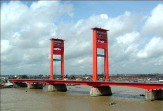
Situated on the eastern side of the Bukit Barisan mountain range the province of South Sumatra is relatively flat, nevertheless fertile, as numerous rivers crisscross and meander through out the region. Part of this province are two sizable islands called Bangka and Belitung, off Sumatra's east coast in the South China Sea. Palembang, its capital city and gateway to the province, lies right on the banks of the great Musi river, 60 km upstream and navigable by oceangoing vessels. No wonder that most major social and economic activities should center in and around Palembang and the Musi river where the region's pride, the Ampera Bridge, is found as well. 

Because of its sheer location on the southernmost rim of the South China Sea and close to one of world's busiest sea lanes linking the Far East with Europe, the region's historical background is undoubtedly rich and colorful. Once the very site of the Buddhist Kingdom of Sriwijaya, it practiced a bustling trade with then ancient China during its era of dynasties.
Inevitable of course, were the interacting forces of the two different cultures at the time which nowadays are still noticeable as consequences of the past.
Visitors can easily reach South Sumatera by air through four major airports at Palembang, Pangkal Pinang, Bangka and Belitung islands, all having direct connections with Medan, Batam, Padang, Jakarta, and not long from now with Singapore too. Air-conditioned buses from points North and West of Palembang are regularly available, as well as from cities on Java and Bali.


PLACES OF INTEREST

The Musi River

By Javanese standards the Musi river is both very broad as well as long, comparable to those found on the big island of Kalimantan, formerly Borneo. The river flows right through the city, cutting it in two halves called the Ulu bank and the Ilir bank and linked by a bridge of considerable size and length, called the Ampera Bridge. If visitors do not care to make an interesting or unique boat trip down the river, they could still take a walk halfway over the bridge to see the vast panorama surrounding them, rare at any other place in Indonesia. Down below they will see unbelievable traffic of boats, big and small, crisscrossing water lines without accidents as if steered by the most able navigators. From the same spot both halves of the city are clearly visible as well. And if the time is right, sunrises and sunsets as witnessed from the bridge would be an unforgettable sight of beauty. Worthwhile noticing are the floating restaurants and shops on both sides of the river, and other curious scenes of daily habits of the city's inhabitants.

An annual event is the Bidar Race, held on or around Independence Day, each 17th of August. Measurements of the competing boats are 24 1/2 m long and only 0.75 m wide, each boat carrying as many as 50 oarsmen.
"Limas", the traditional house

Another interesting item to see is the Limas house which are still found scattered over the province, most of them built on riversides, however, not facing the waterfront. One explanation could be that daily household activities can be done in full privacy, out of sight of passers-by.

These very ornate wooden houses built on stilts have rather sizable measurements: from 15 to 20 m in width and from 30 to 60 m in length. A good part of the house has hand-carved columns, door and window frames and cross ventilation between the rooms by placing wooden panels with flow-through carvings just below the ceilings. Indeed, it would almost be a must to observe the architecture and style of these Limas houses, some of them open to the public.
Ki Kede Ing Suro ancient cemetery

This cemetery dates back from the 16th century where as many as 38 ancient tombs are found of which one of them belongs to Ki Gede Ing Suro, one of the prominent forefathers of South Sumatera's present society. Notably, these 38 tombs are found under one roof of one building.

The State Museum
Relatively new the building was erected in 1977 only, however, its collection of around 2000 relics and antiquities originating from the province itself would make a visit here definitely worthwhile. See ancient household articles, utensils, looms, hunting tools, a bridal room and some preserved animals of the region.
Bangka Island's Matras Beach

Bangka can best be reached by air from Jakarta by scheduled flight in just about an hour by jet. However, boat service from Palembang to either Muntok or Pangkal Pinang is adequate and should not take more than an overnight voyage. This island lies right at the mouth of the Musi River in the South China Sea and is one of world's major producers of tin.
A beach of exceptional measurements, 300 - 400 m wide and 6 1/2 km long, called Matras Beach is located 44 km north of Pangkal Pinang, the island's capital. Fine, white and clean sands make this beach area most attractive to sun and beach lovers, whereas at this time the Parai Beach Hotel with 35 rooms already exists right on the beach.

On the other side of the island at Muntok you can find the Ranggam House built in 1921 on the hill overlooking the sea.
It is like a big lodging house where at one time the first Indonesian president was held captive along with some of his close followers during the nation's physical revolution.
The President's car at the time has still been kept in tact and can be seen by the public at the House's opening hours.
Closer to the capital is the Pasir Padi Beach, just 7 km from Pangkal Pinang and is merely a place to rest or swim and sunbathe.
There is no accommodation as tourists normally come to this beach from the city and villages around this place, 4 km long and about 20 to 60 m wide with endless coconut trees to give it a genuine tropical setting.

Belitung Island

Adjacent to Bangka island is Belitung island, another tin producer, with its capital city called Tanjung Pandan. If you are interested in visiting both islands, the best way to do it is to leave by air from Jakarta to either island first, and then cross over to the other one by boat and onward to Palembang to visit the rest of South Sumatera.

To save time, energy and money, it would not be recommended to make a special side trip to either Bangka or Belitung out of Palembang, but rather these three destinations should best be covered in a single line of direction.
The Belitung Tourism Development Corporation is at present in the midst of a huge tourism project at Tanjung Kelayang Beach, half an hour from the capital by car. A complete beach resort hotel with all modern facilities should be finished by 1992 and promises to become a great success for the area because of its proximity to Singapore, Sumatera and Java.
Punti KayuNatural Pine Forest
This recently built recreational complex covers an area of 50 hectares, consisting of four parts: an amusement park, a recreation park, an natural forest, and a man-made lake.
In this complex are to be found a children's playground, a cultural park, a souvenirs shop, restaurants and an information booth. Because of its proximity to the capital and easy accessibility, this complex actually caters mainly to the local inhabitants of the city of Palembang, however, international tourists may enjoy passing a calm day here to watch urbanites amuse themselves.


Tenang waterfall

Rich in the number of small as well as big rivers flowing through this province, waterfalls of various sizes come with them too. The biggest in the region is the Tenang waterfall where the water smashes down from a height of 90 meters into a deep pool and further downstream in a strong current. By public transportation it takes 2 hours from Palembang, however, less by private car. Located in the Muara Enim regency.

Kamero Island
Forty kilometers from Palembang, Kamero Island is a popular recreation site in the middle of the Musi river. the island has a Buddhist temple.


11/23/2009

Papua


Irian Jaya


 It was the Spaniard Ynigo Ortiz de Retes who, in 1545, gave the name Nueva Guinea to a strip of land on the north coast of the world's second largest island (after Greenland), which is now half Indonesian, half Papua New Guinean territory. Irian Jaya, the western half of the island, is Indonesia's biggest province of about 410,000 square kilometers, representing almost 21 percent of the country's total land area. More than 75 percent of the land is covered dense by tropical forest with only about 1.5 million people, with an average population density of 2.8 persons per square kilometer, the lowest in Indonesia. Jayapura the neat provincial capital on a hillside overlooking the bay, is 3,520 kilometers away from Jakarta.


Irian Jaya is a land of exceptional natural grandeur. Its jungles are among the wildest, most impenetrable in the world. Eternal snow cape mountain ridges more than 5,000 meters high, with walls plunge hundreds of meters down onto floors filled with small glacier lakes. It has scenic beaches in abundance as well as immense stretches of marshlands. Cool grassy meadows lie at the foot of the towering mountains. Rivers cut through dark forests until their sluggish, crocodile infested mouths disgorge the water into the sea.


The highest peak of the central mountain range is Puncak Jayawijaya (5,500 meters). Second and third are Gunung Trikora (5,160 meters) and Gunung Yamin (5,100 meters), respectively. The biggest lake is Paniai, followed in order of declining size by the lakes Ronbenbai and Sentani, both in the vicinity of Jayapura, and Anggigita near Manokwari.


On the basis of physical features and differences in language, customs, artistic expression and other aspects of culture, the indigenous people of Irian Jaya are distinguished into about 250 sub-groups, although they all belong to the Melanesian race, and are related to the people inhabiting the islands along the southern rim of the Pacific.  The Negritos are believed to have settled on the island first, probably some 30,000 years ago, followed by the Melanesians. The people of the central highlands still maintain their ancestral customs and traditions, and are virtually untouched by alien influences. Most of the changes have so far taken place among the coastal people, who are being subjected to ever increasing contacts with the world outside.

This process of change is being accelerated by the work of missionaries, who have been working for many decades among the local populations. The people of the north and west are mostly Protestants, while those of the south and of the hinterland around Enarotali are Roman Catholics. Those around Fakfak and the Raja Ampat Islands are mostly Moslem. Animism is still practiced by isolated tribes in various parts of the province.

Although Irian Jaya is famed for its Bird of Paradise, the province's fauna is not particularly rich. Almost all the animals here are of the Australian fauna type. Copper, oil, timber and sea products like fish and shrimps are among the province's main products.

PLACES OF INTEREST

Jayapura

Jayapura is the capital and the biggest city of this easternmost province. It is a neat and pleasant city, built on the slope of a hill overlooking the bay. General Douglas Mc Arthur's World War II quarters still stand here. The Museum Jayapura is located inside the Cenderawasih University campus. Tanjung Ria Beach, known as base G by the Allies during World War II, is a popular holiday resort with facilities for water sports.

From Skyline in the hills behind the city, one gets a beautiful view of Jayapura, Jotefa and Humboldt bays and the lake Sentani area.
Biak
Biak, a town built on the rocky soil of an island of the same name on the rim of Cenderawasih Bay, is Irian Jaya's gateway. A big Indonesian naval base, it has an infrastructure that is better than in most other places in the province. Japanese caves are found near Ambroben.
There are some good beaches on Biak island, the most popular of which are Bosnik on the east coast, good for swimming and skin-diving, and Korem on the north coast, where one can watch young men dive for pearls. Supiori Island, just north of Biak, has a recreation forest and villages where visitors are welcome.
Kasuarina Cape
Named after the big casuarina trees which grow in the area, Kasuarina Cape is just two kilometers from Sorong town on the Bird's Head peninsula of northern Irian Jaya. Good for swimming and recreation.
Lake Sentani

There is a settlement on the shore of this lake not far from Jayapura where one can observe local traditions as they are practiced in the daily lives of the people. The short trip from Jayapura, pleasant as it is, offers a little foretaste of the province's magnificent sceneries.


 The Asmat

The Asmat homeland comprises the rugged and isolated southern coast of Irian Jaya. It is an area of approximately 10,000 square miles and comprises mainly swamps and mangroves.
Ancestor figures were traditionally made only for the festival honoring Fumer-ipits. They wear a unique costume. Tourists demand, however, is as resulted to change to this custom. Previously, after the festival, the figure is discarded into the forests near a sago tree because it was believed that as the wood of the carving is deteriorated, the power of the ancestor was transferred to the sago palm. Other ancestor carvings are designed as elements in larger carvings, such as canoe prows, paddles or ancestor poles.
The Asmat people who live along the remote southeast coast around Agats are famed for their artistic "primitive" woodcarving. Modern civilization did not reach this area until recently. Agats has an interesting museum filled with woodcarvings and other objects.
The area, however is still largely untamed wilderness. Asmat crafts received a boost in the late 1960s under a United Nations supported project to encourage local craftsmen to keep alive their art. Daily flights are available between Jayapura, Jakarta and Ujung Pandang. In addition, there are weekly flights to and from Ambon, Surabaya and Bali.


PT. Pelni has regular service between Jakarta, Surabaya Ujung Pandang, and Jayapura in comfortable passenger ships.
Places in the vicinity of Jayapura such as Skyline and Lake Sentani can be reached by taking a minibus. Biak has air and sea links with Jayapura. Sorong, is also served by air from Jayapura. Other destinations are reached by car or boat, or by light aircraft.


11/20/2009

North sulawesi


NORTH SULAWESI 

Situated on the northeastern peninsula of Sulawesi, this province stretches further north to smaller islands which almost look like stepping stones to the Philippines.Covering an area of about 27,487 sq. km, it is divided into four districts: Minahasa, Bolaang Mongondow, Gorontalo, and Sangihe Talaud islands, all of which having their different cultures. The capital, Manado is reachable by air from Ujung Pandang, Jakarta, Surabaya, Balikpapan, Ternate, Ambon, and Jayapura. Other airports in this province i.e. Gorontalo, Tahuna and Talaud are served mainly by domestic feather- line traffic.

It is also accessible by sea. The port of Bitung is undoubtedly the most important port, serving shipping lines of the peninsula and the eastern part of Indonesia.


The area is highly mountainous, culminating in 54 peaks, some of which are volcanic and still active. The coast is made up of long stretches of virgin white sandy beaches with magnificent corals and colorful tropical marine life.
Despite their proximity to the mainland, the coral-fringed islets are among the most virgin in Indonesia.
One of the most western-oriented people, the hospitable and open-minded Minahasan people are Christians. Their first contact with the Europeans came in the 16th century with the arrival of Spaniards and Portuguese spice traders. However, it wasn't until the Dutch landed on their shores that they became totally Christianized.

Dutch influence grew, subduing indigenous traditions. Minahasa refers to the confederacy of tribes. Monuments bear evidence of ancient systems of tribes and clans.
The western part of the province, Bolaang Mongondo and Gorontalo were formerly small Moslem principalities till the turn of the century. The southern coast is inhabited by sea nomads, a separate ethnic group which originated in the west coast of the Malay peninsula, now slowly disappearing. Remains of the Mokodompis kingdom are found in Sangir Talaud where the people are Christians as well. But there are distinct differences among these four large ethnic groups which are each composed of several tribes using their own dialects, as well as having different staple foods.
Sago is to the people of Sangir Talaud, what corn is to the people of Gorontalo, and rice to Bolaang Mongondow and Minahasa. This already proves wide differences. It is one of Indonesia's richest coconut, cloves and nutmeg producers.

PLACES OF INTEREST 

Manado  

This municipality is the capital and commercial center, the main gateway to North Sulawesi Province. The land structure shows a morphology of wavy slopes and hills in the northern and central part of the city. The southern part is made up of the mountain foot of volcanoes in central Minahasa.

The principal deep-water port of northern Sulawesi, however, is at Bitung, about 48 km from Manado. This seaport carries trade between one island and the others, as well as with Singapore and the Philippines.
For inter-city traveling the road are good, particularly the network linking Minahasa, Bitung, Bolaang Mongondow and Gorontalo.
Bunaken 

About half an hour by a motorized outrigger canoe from Manado, Bunaken island is a veritable paradise for snorkelers and scuba enthusiasts. The coral reef off Bunaken island is particularly good for that and shouldn't be missed while you're in this region. The drop-off wall at Liang Cove is rare in the world, as it's described by international divers as being spectacular with caves, gullies, and caverns harboring an immense wealth of marine life.

The water averages a balmy 28 degrees C and visibility is sensational (over) 30 m. The Bunaken sea garden is rich with colorful tropical marine life.
Manado Tua Island

Manado Tua is the main island of its sister islands group: Bunaken, Siladen, Mantehage and Nain, situated just off Manado city in the Bay. The path to the top takes several hours to climb but the view takes in all the islands in the Manado Bay. Superb for snorkeling and skin diving, and ideal for corals and sponges. The beach is a mixture of white sand and coral formations. Beautiful reefs and coral gardens are also found around the islands of the northernmost tip of the Minahasa peninsula and along the east coast. The reef lines the coast of Tangkoko Batuangus in the area of a nature reserve. A permit should be obtained from the Sub Balai Konservasi Sumber Daya Alam (Nature Conservation Office) in Manado, before heading for this reserve.  
Tara-tara,
About 15 km further southwest from Tasik Ria this village has traditionally been the center of Minahasan culture and arts. In Tara-Tara traditional dances can be enjoyed in the open air at Kemer Garden. There are World War 11 Japanese caves at the Ranowangko dam, and the Kemer natural bathing spot nearby in the shadow of the volcano Lokon, mount Kasehe and mount Tatawiran. Easily reachable from Manado by public bus or taxi.
Watu Pinabetengan 
A megalithic stone of the ancestors of Minahasa, its surface is covered with crude, mysterious live drawings and scripts which have never been deciphered. According to Minahasa history, this is the place where the ancestors first divided up the land among the people (Watu Pinabetengan means "The stone of discussion about the division"). The ruling was made in order to ensure a peaceful and harmonious life. Seven divisions were made amongst different areas of Tombulu, Tonsea, Toulour, Tontemboan, Tonsawang, Ponosakan and Pasan Ratahan. This is located in Tompaso, about 45 km from Manado.
Tasik Ria

Tasik Ria is situated about 20 km southwest of Manado and has a beautiful sandy beach, with coconut trees. Ideal for sunbathing, swimming, fishing, diving and snorkelingTasik Ria seashore resort has a four-star "Manado Beach Hotel" with 205 rooms, swimming pool, bar & discotheque is a lush seashore resort. Easily reachable by public bus or taxi from Manado.

Waruga

An ancient cemetery of Minahasan ancestors consist of 144 Sarcophagi, which is a remnant of the Megalithic age. It has special historical value. Specific Sarcophagus known as "Waruga" are unique square stones with holes in the middle and prism shaped lids. The artistic aspect of the Sarcophagus is known by the decorative sculpture and carving around the tombs and the lids with various motifs such as of human beings, plants, animals, and traditional geometrical motifs like clouds, strings, curls, double braids. Located in Sawangan village, about 24 km from Manado.

Dumoga Bone National Park

Located on the border between two districts, approximately 260 km from Manado, this park covers Dumoga in Bolaang Mongondow and Bone in Gorontalo. Its mountains and hills covered by dense forests and vegetation make it an ideal reserve of rare and specific animal species like maleo birds, anoas, hornbills, wild pigs tarsius spectrums and fruit bats.
The rainfall favours a very rich flora. A entry permit should be obtained from the Sub Balai Konservasi Sumber Daya Alam (Nature Conservation Office) in Manado. This National Park has several cottages and small restaurants nearby.

Karumenga  Hot baths with water originating from hot volcanic springs attract people for relaxation and health reasons. Located in the village of Karumenga, Langoan, about 50 km from Manado.

Tangkoko Batuangus

A nature reserve on open grassland covered with a great variety of plants. Located on the slopes of mount "Dua Saudara", the area is composed of impressive green hills and valleys with amazingly scenic views of natural beauty. There are black apes, maleo birds, snakes, wild pigs, hornbills and rusa deer. Located north of Bitung, it covers an area of 3,196 ha. This nature reserve has several cottages and small restaurants nearby. It is only reachable by four-wheel drive jeeps from Girian village over a rough road.

Otanaha Fortress 

A shelter and defense base of Gorontalo kings during the colonial era. It is said that the fortress was built with a mixture of sand, calcium and eggs of Maleo birds. Located in the western part of Dembe village, reachable by local transportation.
Lake Tondano - Remboken Tourist Site
About 36 km southwest of Manado is lake Tondano, 600 m above sea level. The drive to Tondano passes through picturesque villages and clove plantations. Situated right on the edge of the lake is the Remboken Tourist site, an ideal place for water skiing, fishing and boating. Bungalows, hot water swimming pool and restaurants are available.

Sarone Island
A beautiful tiny island with its white sandy beach for swimming, boating, snorkeling, diving, and water skiing. It is located in the district of Gorontalo.
Lake Mooat
Situated in the highlands about 900 m above sea level, makes it a cool and nice place to visit. The lake is surrounded by dense forests, abound with birds of various species. It is located in the district of Bolaang Mongondow, reachable by bus.
Ranopaso  This hot water bathing spot is surrounded by rice fields. The hot water sources lay scattered on the ground. Bungalows are available at Koya village, about 3 km from Tondano.
Wale Papataupan  Situated at Sonder village, about 37 km from Manado, Wale Papataupan is a flowery tourist spot which has bungalows, swimming pool, steam bath facilities, restaurants, fish ponds, and an open stage for cultural performances. It is easily reachable from Manado by public bus.


Japanese Caves
A cavernous hill side area along the road between Kiawa and Kawangkoan. The caves were built by the Japanese during World War II, used as supplies storage.
Kasuang
This place is situated about 3 km from Tomohon which has a souvenir shop and restaurants offering Minahasan food. Easily reachable from Manado by public bus or taxi.
Japanese Monument
Since Bitung played an important role during the Pacific War as a home base for the Japanese Imperial forces, it became the last resting place of their soldiers who died in the war. Both the
Japanese and North Sulawesi Government jointly founded this monument.
Shopping Hints
Ornaments of intricately carved wood are common in all districts.
In Sangir the wood used is ebony. In Gorontalo, however, it is rattan. Krawang is a special kind of embroidery from Gorontalo, which is well-known throughout Indonesia.
ACCOMMODATIONS
North Sulawesi is a developing tourist destination. However, its capital city Manado has a three-star hotel with modern amenities. It also has facilities for conventions. Two-and one-star hotels have air conditioned rooms with attached baths. Restaurants are available in all star hotels.


Followers